
When I think of a concept map the first thing that comes to mind is a geographical map. I find it easier to understand when events are placed according to where they happened. Some of the events depicted on my map occurred in different locations so I tried to place them in the general area. This map is a general overview of pre-confederation Canada to introduce the course material. The events are not in depth because there is so much that has happened, the entire page would be full with words. I tried to make it as easy to read as I could with including the information I found to be most important.
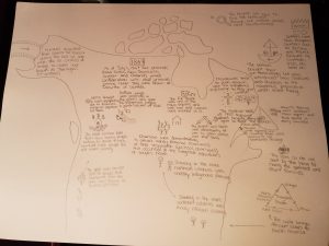
Unfortunately the image is clear on my computer, but is blurry when I upload it to the page. Below is a description of everything on the map (from left to right). The images will be described in brackets and the exact wording from the map will follow after the brackets.
(Picture of a bridge connecting to Alaska.) Humans migrated from Siberia to Alaska during the last ice age when the ice created a bridge to cross over known as “Beringia”. (1st settlers)
(Picture of the year 1867 in a box.) As of July 1, 1867, four provinces (Nova Scotia, New Brunswick, Quebec and Ontario) joined confederation with other provinces joining later. They were known as Dominion of Canada.
(Picture of a face with crossed out eyes.) 1850s brought a mass depopulation due to diseases. Indigenous population hit hard.
(Picture of a mine with dollar signs above, surrounded by many sad people and one happy person.) The 1858 Cariboo Gold Rush saw many people looking to strike it rich, however most people did not make money.
(Picture of many people migrating towards the gold rush.) The gold rush brought lots of people from California into the area now known as British Columbia.
(Picture of buffalo falling off a cliff.) Buffalo jumps were practiced in the plains and gave the Indigenous peoples a good volume of food.
(Picture of a bear with crossed out eyes beside the symbols for male and female.) The Fur Trade was one of the main exports and both men and women were involved in it.
(Picture of a house with many people in front of it.) Charivaris were demonstrations to extract money (marital charivaris) or force resignation (political charivaris) that occurred at the targeted individual’s or couple’s home.
(Pictures of one person telling another what to do.) Slavery in the more northern colonies was mostly Indigenous slavery. Slavery in the more southern colonies was mostly African slavery.
(Picture of two swords fighting.) The English and French were constantly at war to gain control over the land.
(Picture of a religious cross.) Missionaries tried to push religion upon the Indigenous population to help gain control.
(Picture of a man with a speaking bubble.) “This shall be called ‘New France’!”
(Picture of a sad face with dotted lines spreading to many different places.) The Acadian exile of 1755 displaced Acadians because they did not agree to fight the French.
(Picture of a star near the St. Lawrence River.) Jacques Cartier explored the St. Lawrence River while looking for the Northwest Passage.
(Picture of a magnifying glass pointing to the Northwest Passage.) The English set sail to find the Northwest Passage, but instead landed near Newfoundland.
(Picture of a crown with the word ‘Britain’ pointing to the right.) Settlers came from European countries such as Britain and France followed by Scottish, Irish, etc. later on.
(Picture of a boat with a face with crossed out eyes and a gun.) The settlers brought their gun technology but also introduced new illnesses and diseases to the Indigenous population which killed many.
(Picture of dead fish in the ocean.) Atlantic fishing was another main export and food source in early Canada.
(Picture of four girls on a boat.) The filles du roi are sent by the king to marry the settlers and start families.
(Picture of the Triangular Trade showing the connection between Europe, Africa, The West Indies, and North American colonies.) This cycle brings African slaves to North America.